There was only eleven of us signed up for this trip, which made for some comfortable travel and accommodation in Big Yellow. We decided that both the short party and long party would be combined into one party. Setting off from Takapuna, the weather looking over towards the Coromandel Ranges looked a bit showery. The forecast for the weekend was for showers and maybe one fine day out of the three.
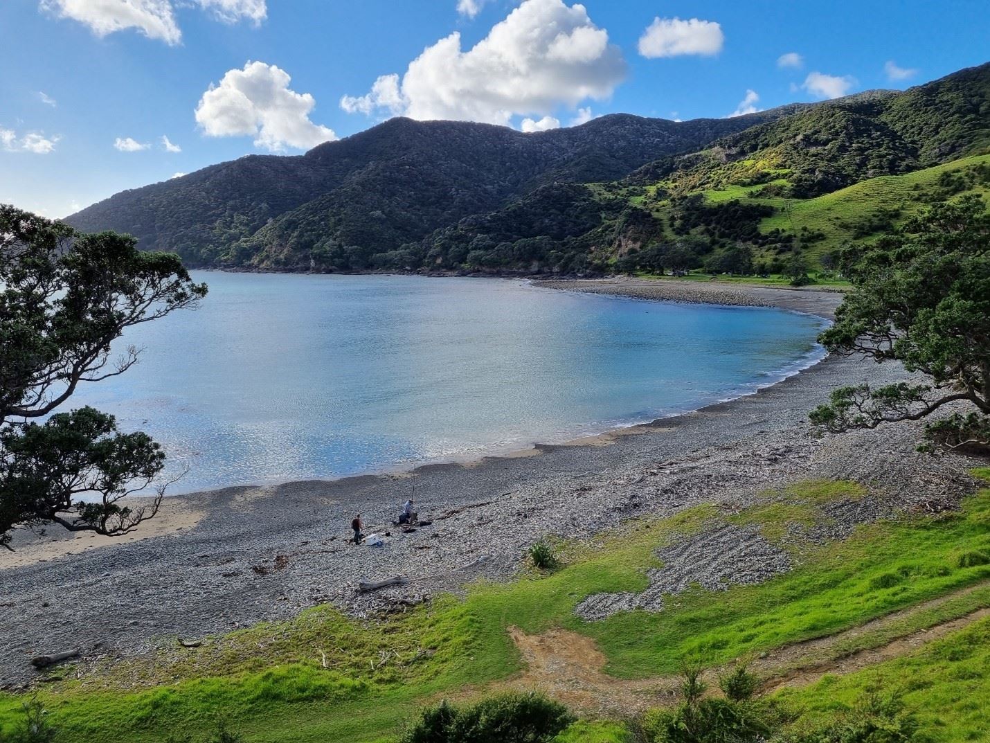
As it transpired, we were blessed with three days of good weather. As per the norm there was the mandatory coffee stop at Thames and a bus refuel as where we were heading, running out of fuel was not a good idea. From Thames we headed up the west coast of the peninsular before crossing up and over the big hill to Te Kouma and on to the small township of Coromandel, for a quick comfort stop. From there we passed the township of Colville and headed over to the east coast of the peninsular, for our first overnight camp at the extremely picturesque bay of Waikawau. We arrived in the practically empty campground at about 1.00pm in time for lunch and to set up camp.
Once we had our lunch, we set off on the Matamataharakeke track which starts at the back of the Waikawau campground. This was an 8-kilometer loop track, which began by crossing the Matamataharekekek stream several times before climbing up a ridge into open farmland to point 344. This gave us great views of Cuvier Island, the Mercury island’s and to the north, the 892-meter mount Moehau, as well as our campground below us.
As the days were getting shorter, it was time for us to complete the three-hour loop by heading down the opposite ridge to our camp. This track was well marked and in places had an exposed clay surface which did prove to be a little slippery but gave us all a good stretch out. Appetites and dinner were upon us in no time, and out came the branded cooking systems, the not so branded cooking systems, and Craig's gadgets, add-ons and salesman talk.
With dinner out of the way by 6.30 pm it was getting dark and much too early for bedtime stories. So, the team under a near full moon decided to take a short evening stroll along part of the expansive Waikawau beach. The moon had influenced Garry somewhat, that would cause him to scare the living daylights out of some of us for fun. We were unsure if it was for his own entertainment or for ours but finally, it was time for us to return to our bus and tents for a bit of reading before a night’s sleep. Having the luxury of sleeping on the bus I found it to be very unentertaining as there were no snorers to listen to when I lay awake, but there was comment I may have slept through the real entertaining solo act of the night.
The following morning, we were ready and aboard the bus by 8.00am, heading towards the beginning of the 10-kilometre Coromandel walkway. But first we had to negotiate the road from Waikawau to Stony Bay. This was an epic twisting, narrow road, so much so that the trip organizer sitting in the back began to worry if we would even make it to Stony Bay! Once we had committed Big Yellow to this section of road, there was no turning back, as there were no areas to turn her around any time soon.
We passed Port Charles and a little further a beautiful bay called Sandy Bay, with all the locals waving to us with big smiles. I am not sure if it was with amusement that we had managed to get the bus this far? or surely, they will not go any further? It is at this stage I must say our club is so lucky to have such a pool of very skilled drivers, both Arletta and Craig for this trip, we thank them dearly for their fine display of driving skills and patience.
After about fifty minutes driving from Waikawau we arrived at Stony Bay. This is as far north on the eastern side of the Coromandel peninsular that you can drive, the road stops at Stony Bay which serves as a doc campsite. We were out of big yellow in no time at all, to commence the Coromandel walkway to Fletcher’s Bay for the night. The track starts with a gentle incline to about 100 meters height and is well graded, which made it easy going. After about 20 minutes we were at our first lookout at the southern end of Shag Bay, we were able to see back towards Stony Bay and the northern end of Shag Bay where our next look out point would be. It was an idyllic coastal setting, blue sky with puffy clouds, clifftops lined with Pohutukawa, Manuka and Pittosporums, the rocks below surrounded by clean clear blue water, it was a real delight.
Onwards we went with another small unnoticed gain in height to the northern end of the Shag Bay lookout. From here we could see further north to where we would be heading Poley bay, and further still the iconic Coromandel walkway promotion shot of Sugar loaf rocks and the Pinnacles, and out to sea the Island of Great Barrier, where our last club trip had been a fortnight previous.
Onwards we progressed to about the 6-kilometer mark where we would descend into Poley bay, some of the team would elect to have their lunch here while the rest elected to get the climb out of Poley bay done with before having lunch.
From there it was out onto open rolling farmland with mouthwatering views of the peninsula’s rocky coastline and numerous lovely small beaches, and not extremely far out to sea Great Barrier, Little Barrier, and the rugged wind-swept little Channel Island. We only had a few more kilometres of farmland before we would reach Fletcher’s Bay camp, some 3.5 hours and 10 kilometres later. Fletcher’s bay is also the furthest north you can drive on the western side of the peninsular.
We just about had the whole camp site to ourselves; it certainly was not too hard to find a place for your tent. Once settled in and after a light snack with cups of tea or coffee, we ventured down to the beach for a look, and for those brave ones amongst us, a swim. As it was getting late in the day and a bit windy, it did not seem very appealing but for the brave, once in the water it was just divine. With daylight hours on short supply again it was not long before we were thinking about dinner and a night’s sleep as the next morning we would be leaving early and retracing our path back to Stony Bay and a return to Takapuna “all in a day’s work” as the saying goes.
Of course, we were fed, packed up and on our way by 8.00am. It took us 3 hours to return to Big Yellow and then we were on our way back to Takapuna. This time we chose to return to Coromandel township via Kennedy Bay and up over the hill to Coromandel for a lunch stop. It was at this stage I decided to try out a famous Coromandel, Mussel chowder pie.
Yes! I can strongly recommend these tasty pies and say, it would be worth the drive to Coromandel just for a mussel chowder pie alone. It was not long after that, and we were back at Thames and waving the Coromandel peninsular goodbye. Heading toward the southern motorway, thinking of what traffic congestion we would encounter at the end of a long weekend, thankfully proved to be a non-event, and we were back at Takapuna before 5.00pm.
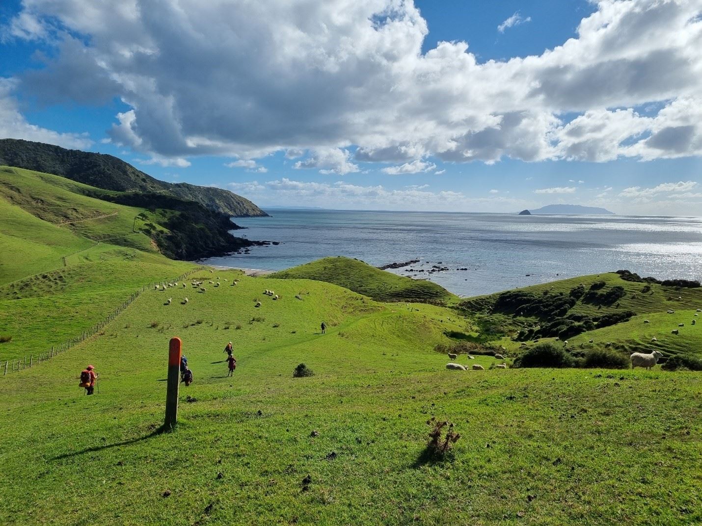
 Looking down from point 344 at Waikawau beach and campground. If you look hard, you will see big yellow in the campground, it had turned a little yellow looking from above.
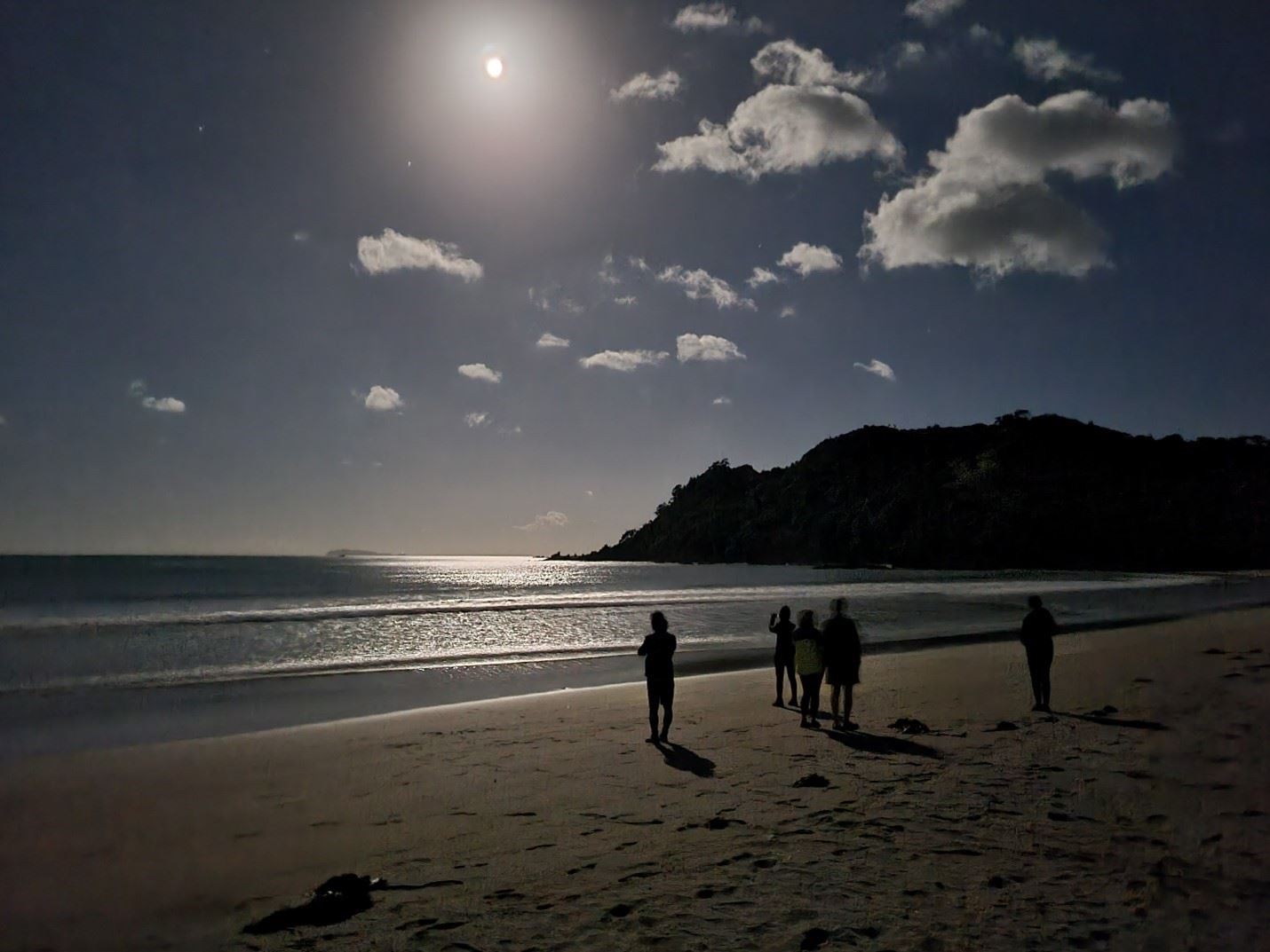 Evening walk under a near full moon, southern end of Waikawau beach.
 Our five-star accommodation on wheels, big yellow awaits us.
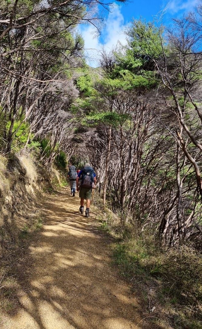
The easygoing and well graded Coromandel Walkway track.
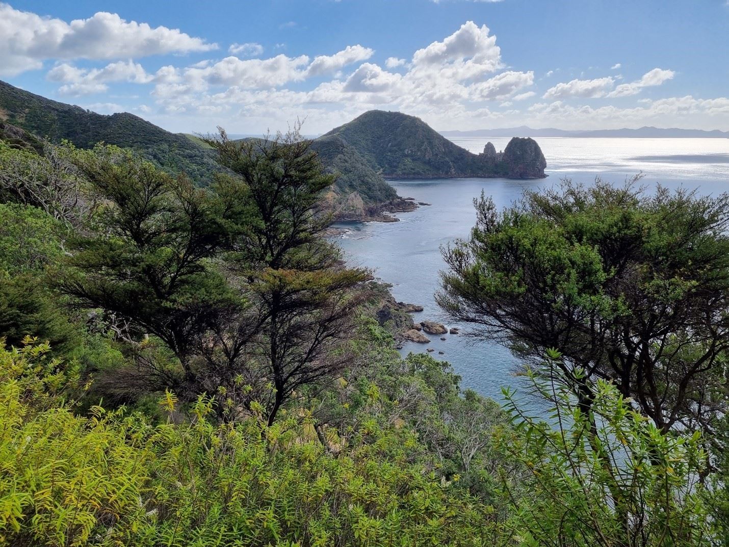 The money shot! From the northern point of Shag Bay looking north, Sugar Loaf Rock and the Pinnacles, Great Barrier in the background.
 Last few kilometres of rolling farmland to Fletcher’s Bay. Channel Island and Little Barrier in the background.
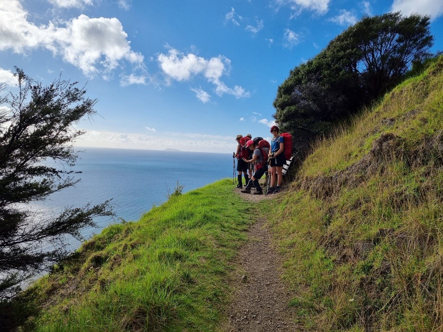 A small break after the climb up from Poley Bay on the return trip. Cuvier Island looking east in the distance. Great Barrier in the background.