MT WILLIAM TO MERCER
Members please register so we can assess attendance numbers.
Mt William and Te Araroa from SH2 to Mercer. Start in Auckland and finish in the Waikato! 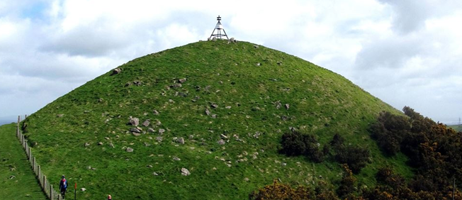
This is a two-part walk; mostly flat but with some steady but easy farmland climbs in the first section.
The first part takes in the highest point of Mt William, descending into attractive bush. There are a couple of climbs but nothing too serious, the descents can be slippery after rain. The second part includes part of the Te Araroa walkway which follows the Mangatawhiri river.
Starting at the Mt William Walkway we traverse through private farmland following the hills to Mt William (373m the highest point of the day), providing great views in all directions. Keep an eye out for the friendly sheep. A steady descent through bush, with some well-maintained stairs takes us to the bus waiting for us at McMillan Rd. Duration around 2 hours.
We will take an early lunch break before getting back on the bus. Distance approx. 5km.
A short shuttle trip along SH2 takes us to a drop-off point past the Mangatawhiri River bridge, on the Te Araroa route on its way to the Waikato River. After a 100m or so walk along the road we hit the farmland following the Mangatawhiri River from the SH2 bridge south-west to the exit at McIntyre Road. This section is open, flat farmland walking alongside the canal.
From there a short road walk takes us to a further section of the trail, (walking below the main state highway) to Mercer service centre and the waiting bus.
Duration around 2.5-3 hours. Distance approx 11km.
Total distance for the day 16km.
Be prepared for cold winds at the high point and along the open farmland sections.
Depart: 9.00 The Strand, Takapuna
Driver: Chris Peard
Cost: $15 members, $20 non-members
Organiser: Amber 027 838-9483
· Non-members: Please phone the organiser to check suitability of the tramp. No texts please.
· See the Club website for full details about Covid restrictions.
Maps Online / Printable / GPS
To access the printable maps, download the zipped file, and either:
· open the zipped file, then drag the files to a new location OR
· press and hold (or right-click) the zipped file, select Extract All, and then follow the instructions